%20(1)%20(1).gif)
Know Where to Look First After the Next Earthquake
Identify which residential buildings may be most vulnerable — and where to prioritize response.
Using parcel data, building age, and seismic indicators to guide faster, more effective decision-making.
Request Data Briefing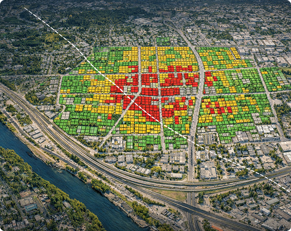
Earthquakes don’t provide warning. Preparation requires clarity.
After an Earthquake, Where Do You Look First?
Following a major earthquake, emergency managers must make immediate decisions about where to deploy limited inspection and response resources. Inspection teams cannot be everywhere at once.

In many cities, thousands of residential buildings were constructed before modern seismic standards were adopted. Without structured data, responders must rely on incomplete information when prioritizing their response. Mapping Seismic Data helps cities identify patterns in older residential construction so inspection teams can be directed where attention may be needed first.
A Better Way to Prioritize Response
Identify where vulnerability may exist before the earthquake.
Mapping Seismic Data analyzes parcel data, building age, and seismic indicators to identify residential patterns that may experience greater earthquake damage.
The resulting datasets help cities prioritize inspections, allocate resources, and strengthen preparedness planning.
Request Data BriefingDeveloped from real-world emergency management experience
Seismic Indicator Analysis
Cross-referenced parcel records with regional seismic risk factors
Residential Parcel Screening
Planning-level identification of properties for inspection prioritization
GIS-Based Delivery
Spatial datasets compatible with city GIS platforms and response systems
Executive Briefings
Clear, decision-ready presentations for city leadership and council
What Cities Receive
01
Residential Vulnerability Screening
Planning-level identification of residential properties that may warrant additional inspection following a major earthquake.
02
Multi-Family Housing Analysis
Identification of apartment complexes and multi-family housing clusters where structural vulnerability may be concentrated.
03
Manufactured Housing Mapping
Identification of mobile home and manufactured housing communities that may require special response considerations.
Extended Capabilities
Additional Services
Executive Leadership Briefings
Executive briefings for city leaders explaining how MSD datasets support earthquake preparedness and response planning.
Data Support for Preparedness
Customized datasets and maps that support emergency planning, training exercises, hazard mitigation strategies, and council briefings specific to your community.
How Cities Use the Data
Emergency Response Planning
Identify where inspection teams should deploy first after a seismic event.
Training & Exercises
Design realistic earthquake response scenarios grounded in actual parcel data.
Hazard Mitigation Planning
Support community resilience initiatives with evidence-based spatial data.
Council Briefings
Provide city leaders with data-driven insights to support policy decisions.
From Data to Decisions
A structured four-step process that transforms public parcel records into actionable seismic intelligence.

Parcel Data
Collect public parcel data and building records.

Screening Indicators
Apply screening indicators and seismic risk factors.

Vulnerability Patterns
Generate GIS-based vulnerability maps.

Prioritized Response
Support preparedness planning and response strategy.
Start with a Data Briefing
Most jurisdictions begin with a short introductory briefing to see how MSD screening datasets could apply to their community.